

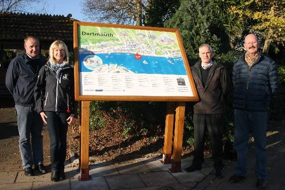
A town map and tourist information board put up in Dartmouth’s Royal Avenue Gardens has been labelled an embarrassment.
At this week’s town council meeting, mayor Richard Cooke criticised it for its “spelling mistakes” and Cllr Paul Allen said it was inaccessible for disabled people or those under 5ft 6ins tall.
The new information board, placed in the wide entrance to Royal Avenue Gardens, shows a map of part of Dartmouth and local businesses and attractions.
It has been criticised by Cllr Paul Allen as “inaccessible” and by Cllr Richard Cooke for its “spelling mistakes” and by one resident as an “embarrassment”.

A spokesman for the visitor centre, speaking ahead of Monday’s council meeting, said: “Director Gina Coles managed the project, working closely with manager Karen Perrow, and it was designed by Jeff Cooper, of We Make Magazines, who produces the Discover Dartmouth guide.
“The project has been spearheaded by Dartmouth Town Council, as a focal point for visitors, showing attractions, shopping streets and buildings of interest or historical importance. The much-needed map, in attractive pastel colours, is a replica of the one produced in the annual town brochure given away at the visitor centre.”
Cllr Coles said before the council meeting that it took a long time to materialise but she was very grateful to everyone that helped.
She said: “This is a prime example of how people who care for the town can come together to make things happen.”
At the council meeting, Cllr Cooke said: “I only saw it this afternoon. It’s got quite a few spelling mistakes in it.
“Most of the map is river but since I’m reasonably tall, I can read it but shorter people have told me it’s difficult to see.”
Cllr Paul Allen, addressing fellow councillors, said: “Are you as disappointed as I am with the new sign which shows ‘You are here’? It is not accessible for disabled people or people under 5ft 6ins tall.
“I don’t know who gave permission for it in Royal Avenue Gardens but there is a great lack of thinking about its position and height and, dare I say, its content.
“I am quite disappointed. Can I suggest we send a letter to the authors of it and make some recommendations?”
Residents had mixed opinions. Speaking to the Chronicle this week, Annette Rosser said: “It is an embarrassment to the town.
“The erection is gross and, to my irritation and embarrassment, people are saying: ‘Go look at that erection and if you can find the deliberate mistake – the largest green space is labelled Cornation (sic) Park’.”
But Graham Sands, from Stoke Fleming, said: ”I think its in keeping with Royal Avenue Gardens. It looks alright. I spotted it from the bus and I came to take a look.
“It is about the right height and in the right place.”
Being able to be seen from the road was part of the reasoning behind the positioning of the sign, so that it would be easily seen by those arriving in the town by coach or bus.
But Lynne Pound said: “It should be against the edge and standing straight up. I don’t mind it but it looks a bit like it just landed.
“Anyone short will have trouble reading the top and I don’t like the angle. It’s a bit unclear.”
Dartmothian Terry Prettyjohns looked at the new sign and said: “Why didn’t they put it back there [pointing to the adjacent flower bed] off the pavement. The plants around it could be trimmed and then, the sharp corners, at head height for some children, would not be a hazard.”
And Peter Johnson, treasurer of the Flavel, said: “I’m astounded that the Flavel was not mentioned in ‘Things to do’.”
Visitor centre manager Karen Perrow explained: “Advertisers in the brochure are now offered a space on the map, which not only supports the visitor centre but also highlights the town’s great places to eat, shop and stay. The advertisements will be changed each year so anyone who wants to be included, can be.”
Mrs Perrow added: ”Cadets from the Britannia Royal Naval College helped council staff to erect the map on a sturdy oak frame in the town’s gardens opposite the coach stop-off points along the waterfront.
“But the job wasn’t to prove as easy as first thought when the team hit a ‘concrete road’ under the flowerbed that had been made by American forces during the Second World War to get their tanks to the river’s edge for the D-Day landings.
“The town council’s maintenance team supervisor Dave ‘Whisky’ Walker and Denis Schofield, along with the cadets, worked for more than four hours to get the map installed.
“Mr Cooper [of We Make Magazines], who donated his time and expertise as the visitor centre’s contribution towards the map, said it had been a pleasure working on the project, which brought to life so much of what Dartmouth had to offer.
Just prior to the council meeting, Mrs Perrow indicated the height of the sign had been identified as being too high and there were plans to change its height.
Also ahead of the council meeting, county and district councillor Jonathan Hawkins, who donated £1,000 from his locality budget to the project, said: “I was very pleased to be able to assist Cllr Gina Coles and Dartmouth Town Council and Dartmouth Visitor Centre with this map of the town.
“Hopefully, as visitors come to Dartmouth, this will assist with finding many popular and hidden treasures.”
Cllr Robin Springett, chairman of the town council’s corporate property committee, said the map was an asset to the town he hoped would be well used to “make things happen”.
Cllr Coles had not, at the time of going to press, responded to a request for a comment and, by the time the information board was discussed at the council meeting, she had left.
At the time the Chronicle went to press, South Hams District Council had not responded to an inquiry about whether the new sign had either needed or received planning permission.
Comments
This article has no comments yet. Be the first to leave a comment.